


BRITS are being battered by heavy rain and 75mph gusts as Storm Chandra rolls in – forcing hundreds of schools across the UK to close.
Rush-hour commuters face road closures due to flooding and flights have been cancelled after the Met Office issued a rare “danger to life” alert.
Both amber and yellow weather warnings are in place across the UK – with snow also blanketing areas in the north east of England.
Belfast City Airport has cancelled dozens of flights this morning, while ferry crossings have also been impacted.
More than 300 schools have shut their doors in Northern Ireland – as Belfast Met campuses moved classes online for thousands of pupils.
And more disruption could be on the horizon, after a yellow weather warning for ice was issued in NI by the Met Office.
FLASH POINT
Storm Chandra map reveals worst-hit spot in England as amber warning issued
WASHED AWAY
Nearly 150 flood alerts across UK as Storm Ingrid to hit with heavy rain AGAIN
The forecaster warned cold temperatures tonight after today’s heavy rain could see “icy patches” forming until 10am tomorrow.
In England, seven schools have been forced to close in Herefordshire amid concerns for the safety of both staff and pupils.
Areas of Dorset, Somerset and east Devon have been hit with severe flooding – forcing roads across the areas to close.
Drivers left their cars stranded and submerged in 3ft-high water at Weycroft Bridge in Axminster, Devon.
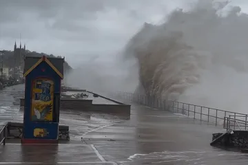
Shocking images showed a £350,000 seaside chalet had been wiped out by gusts and heavy rain on nearby Branscombe Beach.
Trees have also come crashing down due to the gusts in some residential areas – missing homes by yards.
Snow ploughs have even been called in to clear roads for rush-hour commuters in County Durham.
The M48 Severn Bridge was completely closed, while the Humber Bridge was shut to high-sided vehicles due to wind.
Passengers watched on as landings as Leeds Bradford Airport were affected by strong gusts and heavy rain.
Great Western Railways has been forced to cancel services after railway lines were blocked by severe flooding.
Motorists travelling between England and Wales are also being diverted over the M4 Prince of Wales Bridge.
There are 69 flood warnings in place across England, with the majority in south-west England and four in Yorkshire.
The Met Office had warned up to 50mm of rain could fall in south Devon, much of Dorset, southern Somerset and south-east Cornwall overnight.
Pictures showed the south coast getting battered – with huge waves seen crashing against sea walls in Weymouth, Dorset.
Some 25 people stuck in vehicles stranded by flood water were rescued by firefighters in Devon and Somerset.
A spokesman for Devon & Somerset Fire & Rescue Service confirmed there were no casualties.
Yellow warnings for rain are in place across southern England, parts of northern England and Scotland.
Five primary and two secondary schools were shut in the West Midlands due to severe flooding after a night of heavy rainfall.
A yellow warning for wind covers Cornwall, south-west Wales and parts of northern Devon from 5am to 4pm.
And a yellow wind warning is in force for southwestern Scotland until midnight.
Yellow warnings for rain and snow have been issued for the Pennines and south-west Scotland until 5pm, where 5cm of snow could fall.
As much as 10-20cm could accumulate across mountainous areas.
There is a further yellow warning for rain and snow across much of central Scotland from 6am to midnight.
A yellow warning for rain is in place until midday for much of south-east and south-west England.
Met Office chief forecaster Paul Gundersen confirmed snow could fall in some parts of the UK during the storm.
He said: “Initially, strong winds will impact the Isles of Scilly, western Cornwall and south-west Wales… gusts of 70 to 80mph are possible here.
“Heavy rain is an additional hazard as it falls on saturated ground in Dorset and southern parts of Devon, Somerset and Cornwall.
“As Chandra interacts with colder air further north snow becomes a hazard…
“…with 10-20cm of snow possibly accumulating over higher ground in the Pennines, southern Scotland and the Highlands.
“With a complex spell of weather, its important people stay up to date with the forecast and any warnings in your area.”
National Rail issued a warning that “poor weather may affect South Western Railway services until the end of the day”.
Transport for Wales confirmed a tree is blocking the railway, meaning there are no services between Swansea and Shrewsbury.
Lines in Cornwall, Somerset, Hampshire and Devon are closed due to flooding this morning.
Great Western Railway urged commuters to delay their journey until the services “return to normal”.
Issuing an update on its website, it said: “We have had reports of flooding in the area.
“When flood water rises above certain levels trains may have to reduce their speed or be unable to run through the affected area…
“…debris may have moved onto the rails, or the ground underneath the track may have washed away.
“Flooding can also affect the power supply to the signalling systems or the overhead power lines the trains use.”
Devon and Cornwall Police said there was “significant surface water” and urged drivers not to travel in some areas.
The force said: “There is widespread disruption of the roads particularly across Exeter, East and Mid Devon, with many roads becoming impassable.
“Please do not travel in those areas – Exeter, East and Mid Devon – at this time unless you urgently need to.
“We are experiencing an increase in reports of people coming up against flood water.
“Please do not attempt to drive through it. The weather is improving but rivers are still responding to earlier heavy rainfall.”
RAC‘s Nick Mullender also warned motorists to avoid driving through standing water.
He added: “Do not drive through standing water unless you are completely certain the water is shallow enough and it’s safe to do so.
“In these conditions, drivers need to slow down and stay alert.
“Wet roads can double stopping distances, so taking a cautious, steady approach and allowing extra time to react is essential.”
The Met Office said gusts of 60-70mph will affect eastern Northern Ireland, with possible 75mph gusts in coastal locations.
An amber warning for wind is in place on the eastern coast until 9pm.
At least 30 flights at Belfast City Airport have been cancelled – with 15 departures and 15 arrivals axed.
It affected affected Aer Lingus and British Airways flights – which were all due to serve domestic routes in the UK.
People have been urged to stay away from the coast due to the increased risks of injury and danger to life.
An additional yellow rain and wind warning for the whole of Northern Ireland is in place for the entire day.
The UK Health Security Agency confirmed a number of cold-health alerts across northern England are in place until Friday.
Many parts of the country are still recovering from the chaos caused by Storm Ingrid last weekend.
In Devon, part of the historic Teignmouth Pier was destroyed by crashing waves and strong winds as the coast was battered.
The storm plunged the nation into chaos – with travel delays, power cuts and flooding across the UK.
A destroyed part of the structure was washed away as Teignmouth mayor Cate Williams said the town had “taken a real battering” overnight.
Williams told the BBC the pier, built in 1865, had been damaged by “just wild” waves.
And the extreme weather caused a sea wall to crumble – causing rail services between Exeter St Davids and Plymouth to be suspended.
Read the full article here